Maybe Columbus was born in Espinosa de Henares in Castile, and was the son of Aldonza de Mendoza. She died in childbirth. She has two sons: Alfonso who was murdered at the age of five; and other Rodrigo de Mendoza, who is Christopher Columbus. Acc. to Alfonso Carlos Nunez.
But Columbus, as the navigator signed it, only in POIO, the town. In October 2024 historians said Columbus was from Balearic Islnad, Mallorca under the Aragon Kingdom, but he came from Valencia until 1391, then at Mallorca. 'Columbus was a Catalan and the son of a man from the Republic of Genoa and a Jewish woman from Valentia,' Albardaner told 'Al Jazeera', adding that his conclusions match those presented by the documentary - on 27 Oct 2024. Albardaner detailed how Columbus's claim that he had visited 'all the East and the West' before 1470 - contained in a letter written in 1501 - has been dismissed, especially by Italian scholars.
Ca 920/930: discovered Greenland, however, the Icelandic sagas suggest that earlier Norsemen discovered and attempted to settle it before him.
Tradition credits Gunnbjorn Ulfsson (also known as Gunnbjorn Ulf-Krakuson) with the first sighting of the land-mass. Nearly a century before Erik, strong winds had driven Gunnbjorn towards a set of islands between Iceland and Greenland, later named Gunnbjorn's skerries in his honor. He and his crew sighted islands (Gunnbjorn's skerries) lying close off the coast of Greenland, and reported this find but did not land.
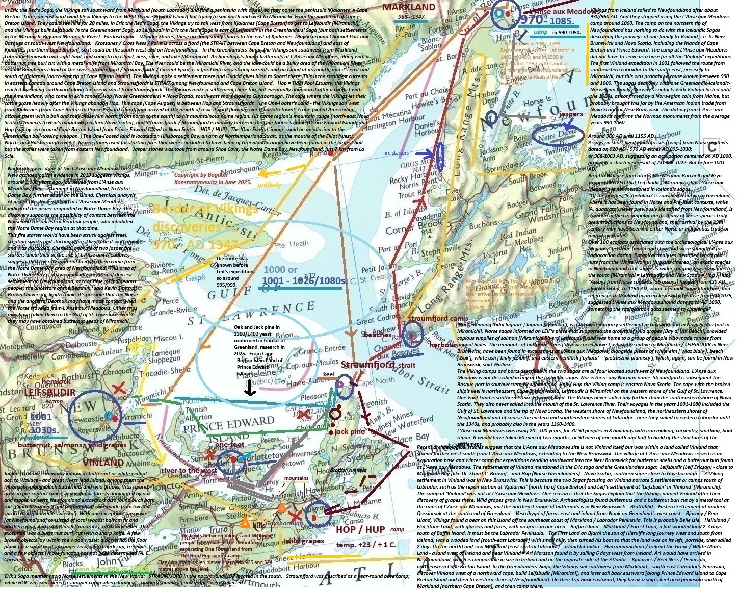
Since Greenland is physically part of North America, separated from Ellesmere Island by only a narrow strait, this sighting could also have been the first European connection with North America. The exact date of this event is not recorded in the sagas. The sagas recount the Vikings' discovery of wild grapes, wheat, and maple trees, leading them to name the New Brunswick land 'Vinland' (land of wine). There in Miramichi, he and his crew built a small settlement, which was called Leifsbudir (Leif's Booths) by later visitors from Greenland. Leifsbudir, meaning 'Leif's houses,' and it served as a base for exploration until 1080s. Leif's brother, Thorvald, later led another expedition to Vinland, using Leifsbudir as a base for their explorations. The Vikings explored the surrounding area: Cape Breton Island, Prince Edward Island and south-east New Scotland, discovered wild grapes, jack pine, wheat. By 'History Extra' in 2017, "by the tale, Leif set off on an expedition to explore the mysterious western land, to be followed later by his brothers Thorvald and Thorstein, and his sister Freydis Eriksdottir, along with the Icelandic explorer Thorfinn Karlsefni. However, in the 'Eiriks saga rauda', Leif has a lesser role, simply spotting the coast of North America in much the same way as Bjarni (blown off course and lost while returning from Norway), and it's Thorfinn Karsefni who leads the main expedition to the area named in both books as Vinland. The 'Graenlendinga saga', written slightly earlier than the 'Eiriks saga rauda', to be the more reliable of the two accounts. Leif calls Labrador as Markland ('wood land'), but he doesn't dwell there long. Winter AD 1000/1001 at Vinland (Miramichi, not L'Anse aux Meadows). Pushed along by a northeasterly wind for two days, Leif from Labrador finally finds the sort of landscape in New Brunswick he's been looking for - fertile and full of food including grapes". This is clear that knowledge on New Brunswick was in L'Anse aux Meadows around 990-1000 / 970-1085. Before Leif, the son of Erick. In spring 1001, "Leif and his crew sail back to Greenland, carrying a precious cargo of grapes and wood. En route, they chance upon some shipwrecked Vikings, whom they save". The small settlement at L'Anse aux Meadows at the northernmost tip of Newfoundland (carbon dating estimate 990-1050 CE) was used before LEIF who knew the sailing route from Labrador to Miramichi in 1000 from unknown Vikings.
Various sources cite dates ranging from 876 to 932.
The first records of purposeful visits to Gunnbjorn's skerries were made by Snabjorn Galti around 978
and soon after by Erik the Red in 982 who also explored the main island of Greenland,
and soon established a settlement in 985 or 986. It was hot here. In winter minus 6, and in Summer up to 20 degrees Celsius in the valleys, much warmer than today. Beetroot and cabbage were grown, cattle and sheep were bred. There were plenty of trees on the coast brought by sea currents. Everywhere grew dwarf trees like large bushes.
In 2019 L'Anse aux Meadows - a 'model A' suggests Norse occupation began AD 910-1030 [around 970 AD], ended AD 1030-1145 [around 1085 AD].
'More than 150 14C dates have been obtained, of which 55 relate to the Norse occupation. However, the calibrated age ranges provided by these samples extend across and beyond the entire Viking Age (AD 793-1066). This is in contrast with the archaeological evidence and interpretations of the sagas'. Vikings from Iceland sailed to Newfoundland after about 930/960 AD. And they stopped using the L'Anse aux Meadows camp around 1060. The camp on the northern tip of Newfoundland has nothing to do with the Icelandic Sagas describing the journeys of one family to Vinland, i.e. to New Brunswick and Nova Scotia, including the islands of Cape Breton and Prince Edward. The camp at L'Anse aux Meadows did not have to serve as a base for all the 'Vinland' expeditions. The first Vinland expedition in 1001 followed the route from southeastern Labrador to the south-east, precisely to Miramichi, but this was probably a route known between 990 and 1000. The sagas deal only with one Greenlandic-Icelandic-Norwegian family.
Norway's contacts with Vinland lasted until the 1080s, as confirmed by a Norwegian coin from Maine, but probably brought this far by the American Indian trade from Nova Scotia or New Brunswick. The dating from L'Anse aux Meadows confirms the Norman monuments from the average years 930-1060.
In Norway rune inscriptions have been found on gravestones indicating that some adventurers not only managed to reach Vinland / Miramichi and Cape Breton, but also returned to Europe for example the Honen Rune Stone from northern Norway contains the words 'from Vinland through the ice'.
Around 1010 Thorn with a crew of 160 men reached Vinland / Cape Breton from Iceland - he sailed along part of the mainland / New Scotland and went so long that he reached a place where it did not snow during the winter at eastern New Scotland.
Mentioned the Honen runestone, discovered in the Ringerike commune, Norway (not northern Norway) in 1817 and now lost. The interpretation by Sophus Bugge, a portion of the inscription is believed to read as "from Vinland through the ice" (or more likely Vinlandi), 50 km north-west to Oslo. The inscription is dated to ca 1010-1050, with the Norse exploration of North America. The inscription is heavily fragmented and lost, but experts have identified "Vinland" within the text, suggesting a hazardous return journey. Old Norse name slightly predating Adam of Bremen's Winland in 1070s. The sketch made by antiquarian L. D. Kluwer (in 1823), copied by Wilhelm Frimann Koren Christie (in 1838), as "from Vinland over ice". The same sequence is read by Magnus Olsen (in 1951) as: 'uin ka(lt)a isa vindkalda a isa / over the wind-cold ice'.
This is a similar situation to Columbus who only sailed again to Haiti / Antilla, known after all exactly after the period 1410/1424. Similarly, the Portuguese sailed to Labrador and Nova Scotia in the years 1495/1499-1520s, only repeating the expeditions from the Azores in the 1470s. The period 1018-1024 at L'Anse aux Meadows is not strongly marked by finds. But we have of course samples dated 1021 AD. The largest number of L'Anse aux Meadows excavations are from the Norman period in the years around 760-780, 840-890, 915, 930-940, 980-995, 982-984, 985-992, 993-996. A clear decline 997-999. An increase in 1001-1009. Again an increase in 1011-1020. The best dated monument - 1021. 'The results, on three different trees, converge on the same year is notable and unexpected. This coincidence strongly suggests Norse activity at L'Anse aux Meadows in 1021'. The decline in the dating of monuments drops sharply after 1070 and disappears altogether after 1150. The period 1010-1030 has only a very weak increase in the number of excavations. 'The remains of eight buildings constructed of sod over a wood frame, with over 800 Norse objects unearthed, including bronze, bone, and stone artifacts, and evidence of iron production'. 'Carbon analysis and artifacts dated the settlement to the period 990-1050 AD. Building remains emerged, typical of the communities in Norse' settlements.
The research in 2018-2019 30 meters outside L'Anse aux Meadows:
it suggests a potentially longer than assumed period of L'Anse aux Meadows use, Up to 195 years. "This does not imply a continuous occupation, which, given the shallow cultural deposits, seems unlikely. Rather, it indicates the possibility of sporadic Norse activity beyond the early 11th century!".
Around 960 AD until 1155 AD.
Assays on short-lived macrofossils (twigs) from Norse contexts dated on 920 AD - 970 AD either AD 895-1030;
or 968-1063 AD, suggesting an occupation centered on AD 1000, provided a shortened result of AD 986-1022. But before 1001 AD!
Birgitta Wallace [and others like Meghan Burchell and Bryn Tapper] PROVED that Leifsbudir = Miramichi; but L'Anse aux Meadows is not mentioned in Icelandic sagas.
"Of the beetles, 'S. metallica' is considered native to Greenland, where it has been found in Norse and Pre-Inuit contexts, while 'A. quadrata', never previously identified from Newfoundland, is common in the circumpolar north. If any of these species truly are introductions to Newfoundland, their arrival by the 13th century may have been via either Norse or indigenous trade or migration routes".
Over 100 ecofacts associated with the archaeological L'Anse aux Meadows heritage (wood and charcoal) were submitted for radiocarbon dating. Botanical analyses identified wood and nuts from the White Walnut (Juglans cinerea), an exotic species in Newfoundland that suggests wider-ranging Norse voyages to the south [Miramichi = Leifsbudir; and New Scotia = Hop / Hup].
"Assays from Norse contexts (56 assays) ranged from 420 AD, charred wood, to 1150 AD, wood. Icelandic saga literature, and references to Vinland in an ecclesiastical treatise from AD 1075, suggested L'Anse aux Meadows should date to ca AD 1000, something the radiocarbon data seemed to challenge".
Above data acc. to Paul M. Ledger, Linus Girdland-Flink, and Veronique Forbes.
In 2018, them trench, measuring 0.65 on 1.50 m, was located 30 m east of 'Ruin D'. The new cultural horizon was encountered between 35 and 45 cm and comprised finely laminated. Apparently trampled surfaces containing charcoal, wood debitage, and charred plant remains.
None of the structures are identifiable as animal shelters, nor is there faunal evidence for animal husbandry - the foundation of Norse subsistence in Greenland and Iceland.
Mainly indigenous occupations dated on 880-960 AD; Norse on 950-1120 AD.
Other examples include Acidota quadrata (Zetterstedt), a Holarctic species previously unrecorded in Newfoundland, and Simplocaria metallica (Sturm), a pill beetle considered adventive (nonnative) in Canada.
In 2019 a 'model A' suggests Norse occupation began AD 910-1030 [around 970 AD], ended AD 1030-1145 [around 1085 AD].
And endured for 0 to 195 years. Leif knew perfectly well the direction of sailing from Labrador to Miramchi, straight southwest. Thirty years before him the Vikings were farming at L'Anse aux Meadows. The starting dates are 970/986 according to research from 2018/2019. Leif sailed through the Gulf of St. Lawrence only in 1001.
Greater uncertainty surrounds indigenous occupations, where a start of AD 710-1130, and end of AD 1540-1815 in L'Anse aux Meadows.
Ca 985:
Erik's salesmanship of Greenland proved successful as after spending the winter in Iceland Erik returned to Greenland in the summer of 985 with a large number of colonists. However, out of 25 ships that left for Greenland, 11 were lost at sea; only 14 arrived. The Icelanders established two colonies on the southwest coast: the Eastern Settlement or Eystribyggd, in what is now Qaqortoq, and the Western Settlement, close to present-day Nuuk. Eventually, a Middle Settlement grew, but many suggest it formed part of the Western Settlement. The Eastern and Western Settlements, both established on the southwest coast, proved the only two areas suitable for farming. During the summers, when the weather was more favorable to travel, each settlement would send an army of men to hunt in Disko Bay above the Arctic Circle for food and other valuable commodities such as seals (used for rope), ivory from walrus tusks, and beached whales.
In 985 - colony in south Greenland. This is very warm period. At south Greenland we have cows, horses, grass field, sheep, many timbers at beaches. Wild small aples.
In 986/987 - first Vikings trip to east and south-east Labrador. Great wood country.
Ca 986:
The first voyage, of Bjarni Herjolfsson in about 985 A.D., was accidental and without a landfall. He was trying to sail from Iceland to join his father in Greenland, but was blown past Greenland, ending up in a lengthy detour along the Labrador coast, before reaching his Greenland destination. Bjarni Herjolfsson was an Icelandic man who is told in Granlendinga saga , and it says that he found 'Vinland' (or Markland / Labrador - like G. Cortereal in 1500; G. Cortereal again discovered in 1501, south-west Greenland and south-east Labrador; John Cabot in 1497 re-discovered north Newfounland = Tierra de los Bacallaos = Codfish Land; John Cabot in 1498 re-discovered Tierra de los Bretones / Land of the Bretons / Nova Scotia, and here was FAGUNDES in 1521), that is, he saw it with its thrones. A monument to him will soon be erected on Eyrarbakki, near the town of Drepstokk. Herjolfsson was likely the first European to sight the east coast of North America. While sailing from Iceland to Greenland in 986 CE, Herjolfsson sighted lands that were later determined to be Baffin Island, Labrador and Newfoundland [rather he discovered only three parts of Labrador, but not Vinland]. Bjarni sailed from Eyrum (where Eyrarbakki was later built) and intended to find his father in Greenland. On his way there, he and his high-seats spot a land without mountains and covered with forests. The high seas wanted to fetch water, but Bjarni sailed on and found a land with a glacier, that is, Greenland. It was done. Bjarni says he thinks it won't be Greenland. They ask if he wants to sail to this land or not. "It is my plan to sail close to the land." And so they did, and they soon saw that the land was not mountainous and wooded, and there were small hills on the land, and they put the land on the port side and let the bow face the land. Then they sail two days before they see another land. They ask if Bjarni was still going to Greenland. He said that he did not intend this Greenland but the former "because glaciers are said to be very large in Greenland" They soon approached this land and saw that it was a flat land and wood grew. Then it took off for them. Then the nobles discussed that they thought it would be a good idea to take that land, but Bjarni doesn't want it. They thought they needed both wood and water. "That's why you are unsupplied," says Bjarni, but he was reprimanded by his superiors for that. He asked them to wind the sails and it was done, and they set out from the land and sailed into the sea for three days, and then they saw the third land. But that land was high and mountainous and had a glacier - Grenland.
Compare in Poland: established Bnin, 938/940 in Greater Poland at present.
Quetzalcoatl may be based on a historical person in 10th entury died in 947.
Ce Acatl Topiltzin Quetzalcoatl lived in Tula. Ce Acatl Topiltzin Quetzalcoatl, or '1 Reed, Our Prince Plumed Serpent', was a holy man and patron of the post-classic Toltec city of Tollan which is now thought to be modern day Tula, situated in the state of Hidalgo, North of Mexico City. Prince One-Reed Precious Serpent born ca 895, died in 947, a figure appearing in 16th-century accounts of Nahua historical traditions, where he is identified as a ruler in the 10th century of the Toltecs, by Aztec tradition their predecessors who had political control of the Valley of Mexico and surrounding region several centuries before the Aztecs themselves settled there.
One version of the story is that he was born in the 10th century, during the year and day-sign "1 Acatl," correlated to date May 13 of the year 895, allegedly in what is now the town of Tepoztlan.
Tollan, Tolan, or Tolan is a name used for the capital cities of two empires of Pre-Columbian Mesoamerica; first for Teotihuacan, and later for the Toltec capital, Tula, both in Mexico. The name has also been applied to the Postclassic Mexican settlement Cholula.
According to Toltec and Maya accounts, Ce Acatl Topiltzin Quetzalcoatl lived in Tula for a while before a dispute with the warrior class over human sacrifice led to his departure. He headed east, eventually settling in Chichen Itza in 947.
The Mayan white bearded man called Quetzalcoatl, the feathered snake, god of goodness and wisdom. Others, too, spoke of the bearded white man.
The Incas, in Peru, called him Viracocha, while their neighbours the Aymara called him Hyustus / Chrystus. In Bolivia he was known as the "God of the Wind".
His disappearance and reappearance in the sky represented death and rebirth. They also believed him to be the god of learning, writing, books, and the calendar. In addition, he was the protector of craftspeople, such as goldsmiths. Quetzalcoatl sometimes became the god of wind, known as Ehecatl / Ezechiel.
Quetzalcoatl wandered down to the coast of the 'divine water' (the Atlantic Ocean) and then immolated himself on a pyre, emerging as the planet Venus. According to another version, he embarked upon a raft made of snakes and disappeared beyond the eastern horizon / Gulf of Mexico ie from around Veracruz sailed to Yucatan and Chichen Itza.
The myth of the return of Quetzalcoatl played an important role in the subsequent history of Mesoamerica. When Hernan Cortes and the conquistadors arrived in Mexico in 1517, the Aztec king Moctezuma II was convinced that the Spaniard was Quetzalcoatl, returning as he had promised to do.
Quetzalcoatl, the Aztec god, was a white, bearded man who came from the east and descended to the Americas before the Spanish arrived. He was described as tall, fair-skinned, and fair-haired, wearing long robes and carrying a message of love. Historians from the 16th century recorded pre-Hispanic beliefs about Quetzalcoatl, including:
Bernardo de Sahagun: Wrote that Quetzalcoatl was worshipped in the past.
Diego Duran: Wrote that Quetzalcoatl was tall, dignified, and had long hair.
Bartolome de las Casas: Wrote that Quetzalcoatl was white, had a rounded beard, and came from the east.
Oral legends say that Quetzalcoatl gave humans many gifts, including: a calendar marking the days of the fifth sun, astronomy and mathematics. Quetzalcoatl also promised his people that he would return from the east one day, and the Aztecs waited for his coming. The cyclical return of Quetzalcoatl coincided with the arrival of Hernan Cortez in 1519, and some people believed that the Spaniards were the fulfillment of Quetzalcoatl's promise.
LEGENDS said that a bearded white man, with fair hair and blue eyes, brought super-knowledge to the Maya.
According to some sources, Quetzalcoatl, the Aztec god, was a white, bearded man who came from the east and descended to the Americas before the Spanish arrived. He was described as tall, fair-skinned, and fair-haired, wearing long robes and carrying a message of love. Historians from the 16th century recorded pre-Hispanic beliefs about Quetzalcoatl.
They called him Quetzalcoatl, the feathered snake, god of goodness and wisdom. Others, too, spoke of the bearded white man. The Incas, in Peru, called him Viracocha, while their neighbours the Aymara called him Hyustus. In Bolivia he was known as the "God of the Wind".
Montezuma proclaimed Cortes was in fact Quetzalcoatl himself, come to fulfill the prophecy. He then graciously handed over the keys to his empire.
Mesoamerican peoples believed that Quetzalcoatl created the world when he fought with his brother Tezcatlipoca. They then split a monster into pieces, creating the earth and sky. To create mankind, Quetzalcoatl snuck into the underworld to trick the Lord and Lady and steal some of the bones they guarded. Quetzalcoatl, the God of the Aztecs. He was the Lord of Intelligence. He was described as a tall fair-skinned, fair-haired man, with a beard. It was told he wore long robes and his message was one of love.
Pedro Sarmiento de Gamboa wrote that Viracocha was described as "a man of medium height, white and dressed in a white robe like an alb secured round the waist and that he carried a staff and a book in his hands." In one legend he had one son, Inti, and two daughters, Mama Killa and Pachamama.
The earliest depictions of the feathered serpent deity were fully zoomorphic, depicting the serpent as an actual snake, but already among the Classic Maya, images of the deity began acquiring human features, such as the beard (see the Borgia codex illustration) that he was sometimes depicted with.
Quetzalcoatl - could be known as Red Tezcatlipoca, the 'Flayed One' and associated with the gods Camaxtli and Xipe Totec (god of the Tlaxcaltecans) or as White Tezcatlipoca, the 'Plumed Serpent' or Quetzalcoatl, god of the Cholula.
Quetzalcoatlus, or simply Quetzalcoatl is an Aztec sky and creator god. The name is a combination of quetzalli, a brightly colored Mesoamerican bird, and coatl, which means serpent; it is therefore usually translated as "feathered serpent" or "plumed serpent".
The Aztecs feared that the end of the world would happen every 52 years, marking the completion of a Calendar Round cycle. To prevent this, they held a New Fire Ceremony, where they extinguished all fires and lit a new one, practicing blood sacrifice to appease the gods.
At Tollan, in what is now Tula, Hidalgo, the Toltec people prospered under Quetzalcoatl's reign; they developed trading partnerships across Mexico and Central America. However, according to legendary accounts, Quetzalcoatl was banished from Tula after committing transgressions while under the influence of a rival.
Gniezno, 940/941 at Winter.
In 954 - Hungarian in Bavaria and Svabia.
According to the Knytlingasaga and Fagrskinna, Jomsborg was built by the Danish king Harold Bluetooth (910-985/86) around 960/963. The Jomsvikinga Saga mentions Danish Viking Palnatoki as its founder. Palnatoke raised king Harald Bluetooth's son Sweyn Forkbeard and was a staunch supporter of the old pagan faith.
Harald Bluetooth had allowed Christian missionaries from the Archbishop of Hamburg-Bremen missionary in Denmark and the king himself was baptized around 964
(December 964 ? - and he was probably the family of Dagome/Mieszko of 'Polanie', by the female branch;
Dagome's male line came from Scotisch's Picts in 919 in the 'Polanie' area).
Mieszko I = Burisleif / Buryslaw / Dagome, was married several times: before Dubrava / Dabrawa of Praga, he had a wife GEIRA, the daughter of Danish king, Harald Blatand. Geira had three daughters: Gunhild / Swietoslawa, Geira younger, Astrid.
In 919 in 'Polanie' country, in addition to the Vikings from southern Sweden and Denmark, there were also Picts from Scotland, where the Normans had plundered the coast. A noble warrior-Pict from eastern Scotland born ca 900, was the father of Dagome. He assumed leadership over the rest of Normans around 930 in 'Polanie' area. Between 980 and 984, 'Swietoslawa' older [17/21 years old] married to Eric the Victorious, the King of Sweden.
This Vikings-Picts group maybe left the shores of Scotland on her way to Denmark in 917, and then they came to Wolin in 918 (Jomsburg / Jumna in Pomerania, where the Danes settled), conquered Grzybowo in 919.
Our Pict-viking b. ca 900, had a son Dagome / Mieszko / Burislaw = Buris Leif/Burisleif.
Dagome was born ca 930/935 and he probably came from mixed parents: above warrior-Pict and noble Norman woman of Denmark born ca 913 - maybe the younger sister/half-sister to Harald Bluetooth b. ca 911, because future marriages of the daughters of Dagome-Mieszko, the names THYRA, Dagome, and Normans warriors in the armed team of Mieszko and his son Boleslaw the Great and the introduction of Christianity in Denmark in 965 and in Poland in 966.
Young Dagome had one or two wifes (the first 'Santslaue oldest' ca 920; the second ca 956 - came from Denmark, b. ca 940) before Dubrava, ie ca 955-963.
The Picts were a mysterious people who inhabited northern and eastern Scotland during the early medieval period.
The history of Polanie / Poland ca 860 till 992:
GIECZ, 860-869.
The construction of a new type of powerful early Piast stronghold (the first in Grzybow 915-922). There is a hypothesis that the military buildup in Greater Poland was related to the fall of Greater Moravia.
Vikings siege of Paris, 845; Vikings established Novgorod in 854.
Bjorn Ironside (Swedish: Bjorn Jarnsida) (Old Norse: Bjorn Jarnsida), according to Norse legends, was a Norse Viking chief and Swedish king. According to the 12th- and 13th-century Scandinavian histories, he was the son of notorious Viking king Ragnar Lodbrok and lived in the 9th century, between 855 and 858.
In "Poland" Giecz - established stronhold in 860/869. Vikings in 870 - ICELAND.
In 874: written sources consider the age of settlement in Iceland to have begun with settlement by Ingolfr Arnarson around 874, for he was the first to sail to Iceland with the purpose of settling the land. Archaeological evidence shows that extensive human settlement of the island indeed began at this time, and "that the whole country was occupied within a couple of decades towards the end of the 9th century." Estimates of the number of people who migrated to the country during the Age of Settlement range between 4,300 and 24,000, with estimates of the number of initial settlers ranging between 311 and 436.
Vikings in KIEV and in south Greenland - 882.
In 902 - the Great Moravia defeated by Hungarian.
In 905/906 - Czechia took the Wislanie country.
In 907 - Pressburg, Hungarien in Austria, Hungarian defeted Bavarian. Ca 920 - Czechia conquered the Silesia Lower.
In 919/922: established the first stronghold of Polanie in Grzybowo close to GIECZ.
In 926 - Hungarien in Bavaria and Italy.
Ostrow Lednicki, 930/940.
Poznan, 935/940.
In 919 in 'Polanie' country, in addition to the Vikings from southern Sweden and Denmark, there were also Picts from Scotland, where the Normans had plundered the coast. A noble warrior-Pict from eastern Scotland born ca 900, was the father of Dagome. He assumed leadership over the rest of Normans around 930 in 'Polanie' area.
This Vikings-Picts group maybe left the shores of Scotland on her way to Denmark in 917, and then they came to Wolin in 918 (Jomsburg / Jumna in Pomerania, where the Danes settled), conquered Grzybowo in 919.
Our Pict-viking b. ca 900, had a son Dagome / Mieszko / Burislaw. Dagome was born ca 930/935 and he probably came from mixed parents: above warrior-Pict and noble Norman woman of Denmark born ca 913 - maybe the younger sister/half-sister to Harald Bluetooth b. ca 911, because future marriages of the daughters of Dagome-Mieszko, the names THYRA, Dagome, and Normans warriors in the armed team of Mieszko and his son Boleslaw the Great and the introduction of Christianity in Denmark in 965 and in Poland in 966.
Young Dagome had one or two wifes (the first 'Santslaue oldest' ca 920; the second ca 956 - came from Denmark, b. ca 940) before Dubrava, ie ca 955-963.
The Picts were a mysterious people who inhabited northern and eastern Scotland during the early medieval period.
Harald "Bluetooth" Gormsson / Gormsen, b. ca 911, died 987, was a king of Denmark and Norway. The son of King Gorm the Old and Thyra Dannebod b. ca 893.
Harald Bluetooth ruled as king of Denmark ca 958 until ca 986/987,
the King of Norway in 974 until 985;
named Harald Blatand d. November 987 in Jomsborg/Wolin.
Ca 920/930: discovered Greenland, however, the Icelandic sagas suggest that earlier Norsemen discovered and attempted to settle it before 982.
Ca. 930 to ca. 960:
Bnin 938-940.
Island of Lednicki Ostrow, 930-940.
Poznan, 935-940.
Gniezno, 940/941, winter.
955 -
in 919, in addition to the Vikings from southern Sweden and Denmark, there were also Picts from Scotland, where the Normans had plundered the coast. A warrior from eastern Scotland born ca 900. He assumed leadership over the rest of Normans around 930 in 'Polanie' area. His son was Dagome / Mieszko / Burislaw. Dagome was born ca 935 and he probably came from mixed parents: Pict and Norman woman. Dagome had one or two wifes before Dubrava, ca 955-963.
The Picts were a mysterious people who inhabited northern and eastern Scotland during the early medieval period.
Dagome had three daughters with GEIRA older, a Norman woman ca 958-963,
Geira younger,
Astryda,
and the third was Zygfryda / Zygryda = Gunhilda / Torrada / Storrada / Swietoslawa.
957 -
in addition to the core land of Gniezno, 'Polanie' state also included Kujawy and the Sieradz-Leczyca region. Mieszko probably took power ca 957.
958 -
three daughters of Mestko / Mieszko / Dagome / Buryslaw / Burisleif, were with Geira older, the wife before 963.
Mieszko I born ca 935, d. on 25 May 992 = Buryslaw, his wife Thyra / Geira.
They had three daughters:
1. Geira younger married to Erik Tryggvason.
2. Astryda married Sigwald, earl of Jomsburg / Jumna in Pomerania, where the Danes settled in the second half of the 10th century.
3.
SYGRYBA / STORRADA = Gunhilda / Swietoslawa b. ca 959/963 (= Proud) in Danish it sometimes appears as Gunhilda. Storrada means a person strong in words, proud; Sigryda received this Scandinavian nickname when she burned alive the king of Vestfold, Harald Grenske to warn other from proposing marriage to her.
In one English source, the name of the sister of King Canute, therefore the daughter of Sweyn Forkbeard and 'Piast', was written as 'Santslaue' younger / 'Santslaue soror CNVTI regis nostri', which can be deciphered as Swietoslawa. Since the daughter had such a name, she probably inherited it, as is assumed, from her mother, Swietoslawa older. Maybe the name was inherited from her grandmother, the pagan wife of Mieszko I / Dagome.
958-960 -
Dagome b. ca 930/935, had three daughters with Thyra / GEIRA older b. ca 940, a Norman woman of Denmark; named daughters probably born ca 958-963.
SYGRYBA / STORRADA = Gunhilda / Swietoslawa (Proud) in Danish it sometimes appears as Gunhilda. Storrada means a person strong in words, proud; Sigryda received this Scandinavian nickname when she burned alive the king of Vestfold, Harald Grenske to warn other from proposing marriage to her. Sygryba / Storrada married Sweyn Forkbeard born 963, d. 1014, in 986 the King of Denmark.
Sweyn was the father of
King Harald II of Denmark,
King Cnut the Great,
and Queen Estrid Svendsdatter.
In the mid-980s, Sweyn revolted against his father, Harald Bluetooth, and seized the throne. Harald was driven into exile and died shortly afterwards in November 986 or 987 in Wolin.
Above Harald II was the youngest son of Sweyn Forkbeard and Gunhild of Wenden, and was regent while his father was fighting Ethelred the Unready in England. After his father's death, he was elected to the Danish throne in 1014.
Gunhilda of Wenden was a Polish princess, the daughter of Mieszko I of Poland according to Chronicles of Thietmar of Merserburg, Adam von Bremen and Acta Cnutonis regis princess and Danish Viking Age queen consort, the supposed spouse of King Sweyn I of Denmark (b. ca 963 - d. 1014). Sweyn is also said to have been married to Sigrid the Haughty. She is the Polish Swietoslawa.
Christianity in Denmark took hold more firmly in the 10th century, particularly after King Harald Bluetooth's baptism in 965.
The official conversion occurred during the reign of King Harald Bluetooth, who mounted the throne ca 958. According to Widukind of Corvey, a priest named Poppo convinced Harald to accept that "there is only one true God". Harald "Bluetooth" Gormsson was a king of Denmark and Norway.
The son of King Gorm the Old and Thyra Dannebod.
Harald's rule as king of Norway following the assassination of King Harald Greycloak of Norway lasting for a few years in the 970s. His son Sweyn Forkbeard forcibly deposed him from his Danish throne before his death.
In one English source, the name of the sister of King Canute, therefore the daughter of Sweyn Forkbeard and 'Piast', was written as 'Santslaue' younger / 'Santslaue soror CNVTI regis nostri', which can be deciphered as Swietoslawa. Since the daughter had such a name, she probably inherited it, as is assumed, from her mother, Swietoslawa older. Maybe the name was inherited from her grandmother, the first pagan wife of Mieszko I / Dagome.
Between 980 and 984, 'Swietoslawa' older [17/21 years old] married to Eric the Victorious, the King of Sweden.
Most likely, it was a political marriage, aimed against Denmark, which was to allow Mieszko to strengthen his power in Western Pomerania. The only known children from this marriage were Olof Skotkonung, later King of Sweden, and Holmfryda Eriksdotter.
Swietoslawa older / Sigryda was widowed around 995. Olaf was already in full power. The queen led to the conclusion of a Swedish-Danish alliance against Norway, sealing it with her marriage to the king of Denmark and Norway, Swen Forkbeard, who had returned from exile. This marriage took place around 996. At least five children were born from this union, including two subsequent Danish kings: Harald II Svensson and Canute II the Great, and daughters: Estrida and Swietoslawa younger. When Swen expelled his wife around 1002, she took refuge with her brother, Boleslaw the Brave, in Poland. Swen became king of England in 1013.
After the death of the Danish king Swen, their sons Harald and Canute came to Poland, asking their mother to return to Denmark. The last certain fact of her life is her return to Denmark in 1016. Canute's mother probably accompanied him during his reign in England.
Canute the Great (born 996/997, died 12 November 1035), the king of Denmark and Norway, had two sisters:
Estryda Margaret (born 995, died ca 1057/1073), the wife of earl Ulf Torgilsson,
and Swietoslawa younger, born ca 995/999, died after 1031, the wife of the Slavic prince Wyrtgeorn.
According to this historian the name Swietoslawa older could rather have been by her grandmother, and therefore the mother of Mieszko I. Gunhilda, the daughter of Mieszko, was not the daughter of Dobrawa.
An additional argument is the same name took granddaughter Gunhilda, who could have been named after her deceased grandmother.
Sigryda / Storrada is identified by some historians with Gunhild / Gunhilda.
In 960-990: most warmer period in Middle Ages: hotter then now in 2024. Warm years: 920-1120.
963 -
Mieszko decided to begin paying tribute to the German king from the lands up to the Warta River. This payment likely covered the territory of the Lubusz tribe.
Soon, in 965, the Prince of the Polans married the Czech princess Dobrawa.
The town of Wolin was first mentioned in 965, by Ibrahim ibn Jakub, who referred to the place as Viking's 'Weltaba'. Excavations were dated by dendrochronological method to the period from 965/966 to the middle of the 11th century. Ibrahim ibn Jaqub wrote in Arabic letters about this city. The transcription might be Weltaba, which corresponds to modern Polish Weltawa.
The earliest evidence of fortifications dates to the first half of the 9th century. In the second half of the 9th century, there was a central fortified area and two suburbs. Around 896 AD a new port was constructed and the main part of the town acquired new, stronger fortifications, including a wooden palisade. Archaeologists believe that in the Early Middle Ages Wolin was a great trade emporium, spreading along the shore for four kilometres and rivalling in importance Birka and Hedeby. In 967, the island became controlled by Poland, under Duke Dagome / Mieszko I.
Christianity continues to spread north and east: in 965, king Harald Bluetooth of DENMARK and followed by Duke Mieszko and Poland's leading nobility and also Vladimir the Great, Grand Prince of KYIV, regarded as the founder Christianity in Ukraine, and King Olaf Tryggvason of Norway, who sends missionaries to Iceland and Greenland, and 1008, King Olof Skotkonung of Sweden.
Ca 955 - Miesko / Dagome ruled in Gniezno (his father was Pict and ruled ca 930-955).
In 965 - married catholic bohemian woman Dubrava.
966 - baptised in Ostrow Lednicki, Gniezno or Poznan.
In 905/906 - Czechia took the Wislanie country - beginning of Catholics.
In 907 - Pressburg, Hungarien in Austria, Hungarian defeted Bavarian.
Ca 920 - Czechia conquered the Silesia Lower - beginning of Catholics.
966 -
Mieszko was baptized and began the process of Christianizing his state.
He came into conflict with the Veleti and their leader, the German outlaw and adventurer Wichman. The Veleti defeated Mieszko twice, and in one of the battles around 963, his unnamed brother was killed.
The first Polish bishop, named Jordan, was ordained in 968. He was likely a missionary bishop reporting directly to the Holy See, although historiography suggests that he may have been a suffragan of the German metropolis in Mainz.
In his early years, Dagome/Mieszko led wars against neighboring tribes, seeking to expand the territory of his state. The conquest of Eastern and Central Pomerania likely occurred in the early 960s.
In 967, he won a battle against the Wolinians, thus subjugating the mouth of the Oder River.
Around 970, Mieszko I conquered the lands along the Notec River and built a stronghold in Santok.
This may have led to a dispute with the Lusatian margrave, Hodon.
In 972, the latter attacked Mieszko, despite the fact that the prince of the Polans faithfully paid tribute to the emperor. The decisive battle took place near Cedynia.
After this skirmish, the Polish ruler was summoned, along with Hodon, to the imperial council in Quedlinburg in 973. The emperor's judgment is unknown, but it was likely not favorable to Mieszko.
This, among other things, explains the prince of the Polans' joining the German opposition after the death of Otto I the same year.
Henry the Quarrelsome lost the battle, and the Emperor retaliated against Bohemia, forcing its prince into submission in 978.
In 979, Otto II is said to have also invaded the lands of the Polans, but this expedition likely ended in failure.
980 -
Mieszko contracted a second marriage, this time to Oda, daughter of Dytryk, Margrave of the Northern March. This union weakened Polish-Bohemian ties.
982 -
between 980 and 984, 'Swietoslawa' older [17/21 years old] married to Eric the Victorious, the King of Sweden. Most likely, it was a political marriage, aimed against Denmark, which was to allow Mieszko to strengthen his power in Western Pomerania. The only known children from this marriage were Olof Skotkonung, later King of Sweden, and Holmfryda Eriksdotter. Swietoslawa older / Sigryda was widowed around 995. Olaf was already in full power. The queen led to the conclusion of a Swedish-Danish alliance against Norway, sealing it with her marriage to the king of Denmark and Norway, Swen Forkbeard, who had returned from exile. This marriage took place around 996. At least five children were born from this union, including two subsequent Danish kings: Harald II Svensson and Canute II the Great, and daughters: Estrida and Swietoslawa younger. When Swen expelled his wife around 1002, she took refuge with her brother, Boleslaw the Brave, in Poland. Swen became king of England in 1013. After the death of the Danish king Swen, their sons Harald and Canute came to Poland, asking their mother to return to Denmark. The last certain fact of her life is her return to Denmark in 1016. Canute's mother probably accompanied him during his reign in England.
Canute the Great (born 996/997, died 12 November 1035), the king of Denmark and Norway, had two sisters:
Estryda Margaret (born 995, died ca 1057/1073), the wife of earl Ulf Torgilsson,
and Swietoslawa younger, born ca 995/999, died after 1031, the wife of the Slavic prince Wyrtgeorn.
According to this historian the name Swietoslawa older could rather have been by her grandmother, and therefore the mother of Mieszko I.
Gunhilda, the daughter of Mieszko, was not the daughter of Dobrawa.